
2027 #TheHalf ROUTE
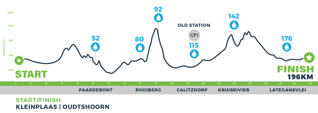
| Ascent | 2 950 m |
| Descent | 2 950 m |
| Distance | 196 km |
| Waterpoints | 52km, 80km, 92km, 115km, 142km, 176km |

Waterpoint 01: Paardebont • 52 km
Waterpoint 02: Rooiberg Bottom • 80 km
Waterpoint 03: Rooiberg Top • 92 km
Waterpoint 04 | Checkpoint 1: Calitzdorp Old Station • 115 km
- All riders have to move through this checkpoint and have their number clipped
- A hot meal will be served
- Rider race containers will be available here
- Back-up vehicles allowed
- Spectator point
- Checkpoint 1
Waterpoint 5: Kruisrivier • 142 km
Waterpoint 6: Lategansvlei • 176 km
 Finish: Oudtshoorn • 196 km
2027 ROUTE MAP
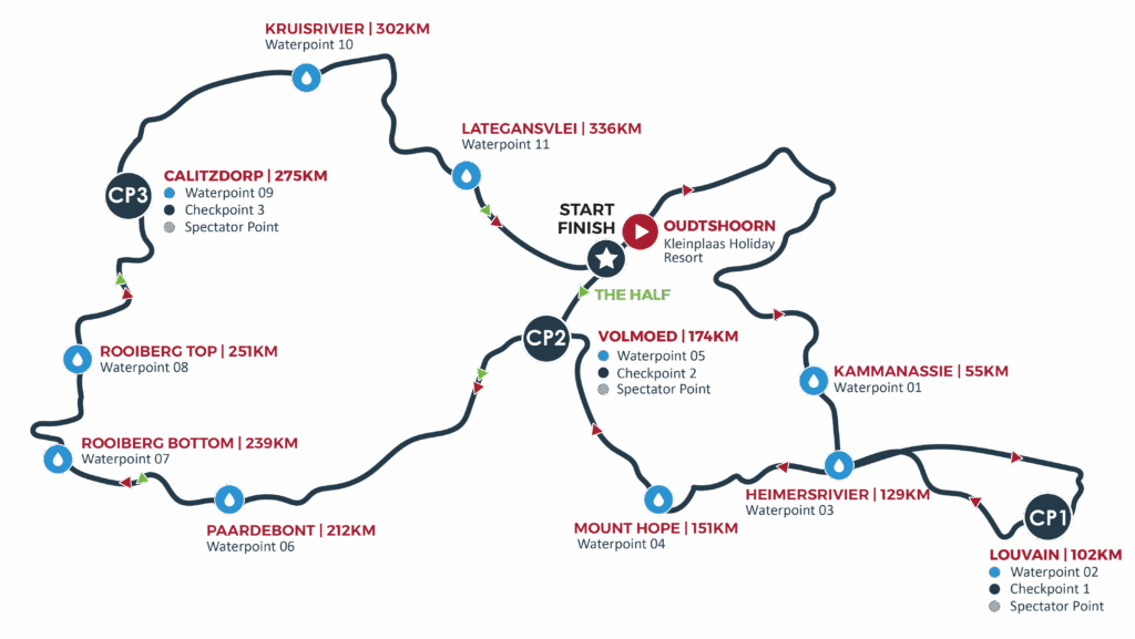
2027 #TheChallenge ROUTE
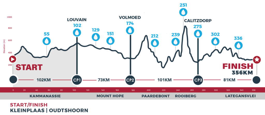
START – CHECKPOINT 1
| Ascent | 1 200 m |
| Descent | 850 m |
| Distance | 102 km |
| Waterpoints | Kammanassie, Louvain Guest Farm |
Waterpoint 01: Kammanassie • 55 km
- This waterpoint will be stocked with coke, electrolyte drinks, fresh fruit and something light to eat
- No back-up vehicles allowed
Waterpoint 02: Checkpoint 1: Louvain Guest Farm • 102 km
- All riders have to move through this checkpoint and check-in.
- Relay riders will complete stage 1 of the relay at this checkpoint, they also have to check-in and do the hand over to the next rider
- This waterpoint will be stocked with coke, electrolyte drinks, fresh fruit and a hot meal will be served
- Rider race containers will be available here
- Back-up vehicles allowed
- Spectator point
- Checkpoint 1
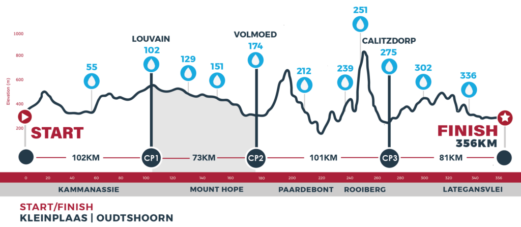
CHECKPOINT 1 – 2
| Ascent | 450 m |
| Descent | 785 m |
| Distance | 72 km |
| Waterpoints | Heimersrivier, Mount Hope, Volmoed |
Waterpoint 03: Heimersrivier • 129 km
- This waterpoint will be stocked with coke, electrolyte drinks, fresh fruit and something light to eat
- No back-up vehicles allowed
Waterpoint 04: Mount Hope • 151 km
- This waterpoint will be stocked with coke, electrolyte drinks, fresh fruit and something light to eat
- No back-up vehicles allowed
Waterpoint 05 | Checkpoint 2: Volmoed • 174 km
- All riders have to move through this checkpoint and check-inn.
- Relay riders will complete stage 2 of the relay at this checkpoint, they also have to check-in and hand-over to the next rider
- This waterpoint will be stocked with coke, electrolyte drinks and fresh fruit
- A hot meal will be served
- Rider race containers will be available here
- Back-up vehicles allowed
- Spectator point
- Checkpoint 2
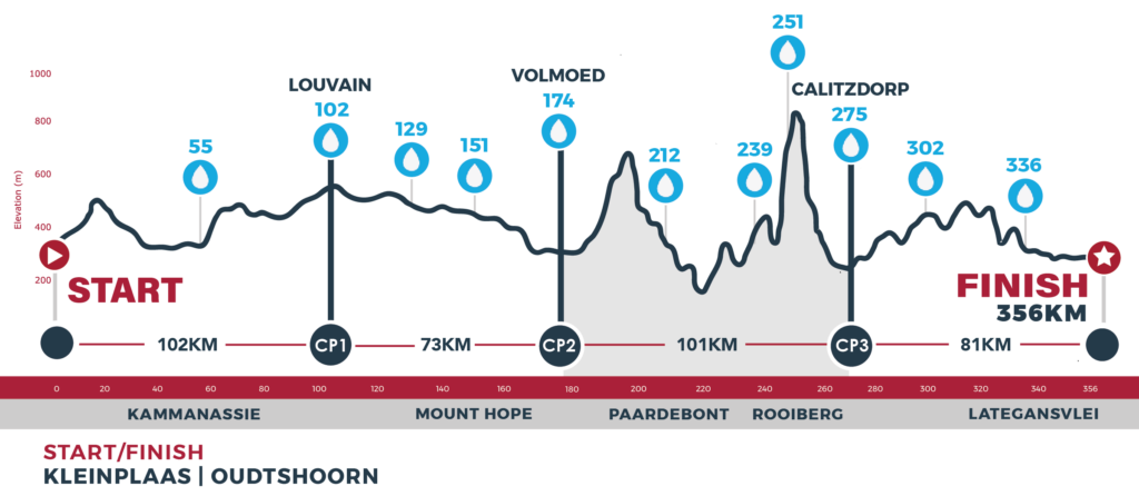
CHECKPOINT 2 – 3
| Ascent | 1 690 m |
| Descent | 1 765 m |
| Distance | 102 km |
| Waterpoints | Paardebont, Rooiberg Bottom, Rooiberg Top, Calitzdorp Old Station |
Waterpoint 06: Paardebont • 212 km
- This waterpoint will be stocked with coke, electrolyte drinks, fresh fruit and something light to eat
- No back-up vehicles allowed
Waterpoint 07: Rooiberg Bottom • 239 km
- This waterpoint will be stocked with coke, electrolyte drinks, fresh fruit and something light to eat
- No back-up vehicles allowed
Waterpoint 08: Rooiberg Top • 251 km
- This waterpoint will be stocked with coke, electrolyte drinks, fresh fruit and something light to eat
- No back-up vehicles allowed
Waterpoint 09 | Checkpoint 3: Calitzdorp Old Station• 275 km
- All riders have to move through this checkpoint and have their number clipped
- Relay riders in the Challenge will complete stage 3 of the relay at this checkpoint, they also have to check- in and hand-over to the next rider
- Stocked with Coke, electrolyte drinks, Biogen supplements and fresh fruit
- Relay riders in the Relay Half will complete stage 1 of the relay here and they also have check-in and hand over to the next rider
- This waterpoint will be stocked with coke, electrolyte drinks and fresh fruit
- A hot meal will be served
- Rider race containers will be available here
- Back-up vehicles allowed
- Spectator point
- Checkpoint 3
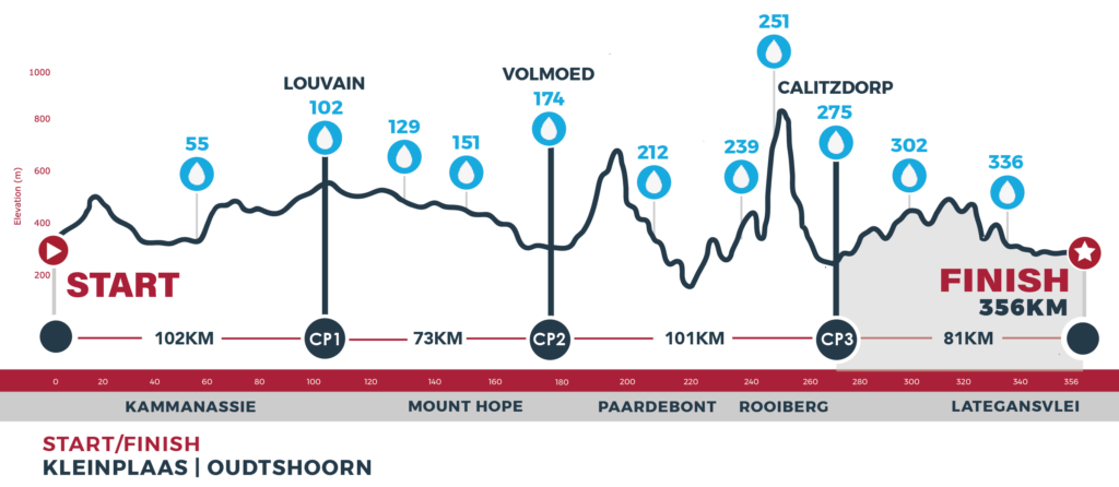
CHECKPOINT 3 – FINISH
| Ascent | 1 240 m |
| Descent | 1 200 m |
| Distance | 80 km |
| Waterpoints | Kruisrivier, Lategansvlei, Oudtshoorn |
Waterpoint 10: Kruisrivier • 302 km
- This waterpoint will be stocked with coke, electrolyte drinks, fresh fruit and something light to eat
- No back-up vehicles allowed
Waterpoint 11: Lategansvlei • 336 km
- This waterpoint will be stocked with coke, electrolyte drinks, fresh fruit and something light to eat
- No back-up vehicles allowed
Finish: Oudtshoorn • 356 km